Railfan Hotspots

Railfanning is a term used to describe people who like to go trackside and watch trains.  The activity may also include things like photography, videography, following trains as they travel through the countryside, and documenting rail activity. The following locations can be found within two hours or less of the beltway. Generally there is a lot of rail activity at these locations.

Amtrak, CSX, VRE – many trains a day. To reach Long Bridge Park, follow US 1 north to Crystal City (just north of Potomac Yard), take the 15th Street exit, immediately turn left onto the service road, then drive straight ahead to Old Jefferson Davis Highway-which currently is quite rough but should be resurfaced soon. Follow Old Jefferson Davis Hwy to the park entrance.

The park has substantial railroad history, not the least of which is its name, a reference to the railroad bridge over the Potomac connecting Washington with Northern Virginia. The property was once called “South Washington,” a railroad location that included industries such as Solite. Just to the north is a 4-acre plot where the Twin Bridges Marriott (1957-1990) once stood (the Marriott company’s first hotel), which the county also owns and will develop in a Phase II expansion of the park. The location marks the northern extreme of the RF&P at RO tower (CFP110), where the Rosslyn Branch of the PRR once turned west on a routing that passed the Pentagon and terminated in a small yard in old Rosslyn.

On the east side of the park they designed a walkway with waist-high railing about 15 feet above track level and running several hundred yards along the railroad, affording largely-unobstructed views that are particularly photogenic in afternoon light. From this high walkway one can also watch water birds taking off and landing at the pond across the tracks, as well as aircraft doing the same thing at National Airport.

Gaithersburg, MD Historic Train Depot & MARC Station

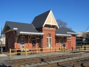
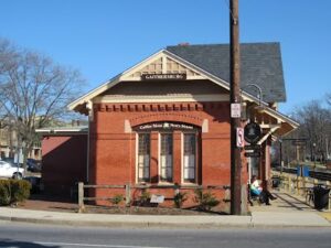
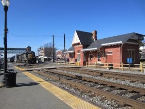
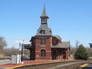
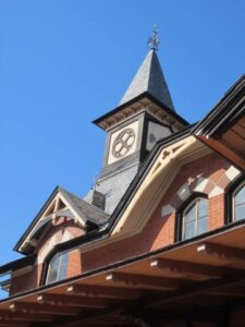
The historic depot is located in the heart of Olde Town at the corner of Summit and Diamond Avenues (5 South Summit Ave.). One of the series of B&O depots designed by the noted architect, Ephraim Francis Baldwin, a number of which still survive, the depot building and adjacent companion freight house were constructed in 1884 and placed on the National Register of Historic Places in 1978. (The original plans are in the archives of the B&O Museum in Baltimore.) Today the depot serves as a central focus of Olde Towne and is a busy stop on MARC’s Brunswick Line.

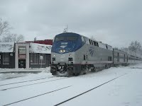
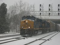
Located on the former B&O Metropolitan Branch, now the CSX Metropolitan Subdivision, the depot sees the passage of a steady stream of CSX freights to and from the west, the morning and evening weekday MARC trains, and the twice-daily Amtrak Capitol Limited to and from Chicago. Summit Ave. is so named because it is located at the crest of the long climb up from the Potomac River at Point of Rocks. As a result, helpers occasionally appear on heavy coal trains.

A unique treat for visitors to the depot is the Java Junction coffee and sandwich shop located inside the station. Patrons can sit in the old waiting room (originally the depot had separate men’s and women’s waiting rooms) on original B&O benches while they dine or sip their coffee and wait for the next train, whose arrival will be signaled by the lowering of the crossing gates at Summit Ave. Java Junction is open M – F until 3:30 p.m. and Sat. until 3:00 p. m. (closed Sunday).

Adjacent to the depot is a History Park which contains a static display of a 1918 Buffalo Creek and Gauley 2-8-0 steam locomotive (freshly painted), a C & O bay window caboose, and a recently-arrived 1950s era B&O RDC Budd car. A small community museum is located in the freight house, which is open Thursday – Saturday from 10 a.m. to 2 p.m.

The depot is easily reached via either exit 10 or exit 11 from I270. From exit 10, turn left at the light at the end of the ramp onto West Diamond Ave.which leads directly to Summit Ave. From exit 11 east, go south on Route 355 for several miles, cross the railroad bridge, and turn left by the Catholic Church onto Summit Ave. There is ample parking at the depot and Gaithersburg City Hall plus there is a large parking garage nearby.

The opening of the Metropolitan Branch in 1873 marked the beginning of the transition of the region surrounding Gaithersburg from agriculture to suburban development. The B&O rerouted most trains from Baltimore to the west through Washington and over the new Metropolitan Branch, relegating the Old Main Line to secondary status. Numerous commuter trains traveled between Washington and Gaithersburg, which was the end of the line and the end of the original double tracking of the Metropolitan Branch. Remnants (very limited) of the wye where they used to turn around still exist. Historic photos can be found inside the depot and the community museum.

Other nearby points of interest include a brew pub directly across the street in the historic Belt building, a farmer’s market on Thursdays during the summer near the site of the former wye, and the picturesque village of Washington Grove which has its own MARC platform. Washington Grove was originally a summer camp run by the Methodist Church to escape the heat of Washington summers.

More information about the City of Gaithersburg and its history can be found at http://www.gaithersburgmd.gov.

Pictures

All Photos by Gail Anderson.

Historic B&O Depot, Gaithersburg, MD

Coffee Shop, Gaithersburg MD Depot

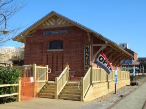
Historic B&O Freight House, Gaithersburg, MD

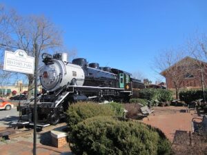
Buffalo Creek and Gauley Steam Locomotive, History Park, Gaithersburg, MD

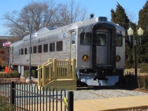
B&O RDC Budd Car, History Park, Gaithersburg, MD

Trash Train Crossing Summit Ave., Gaithersburg

Special thanks to Hank Anderson for contributing to this page.

St. Denis MARC Station

(North Elkridge, MD near intersections of U.S. Rt. 1 and I-195) – really a sparse location (some fast food service about a south on Rt. 1), but more traffic than Dorsey. New signal bridge and interlocking in place right at this location. Freight traffic includes Baltimore-Washington main line and the Old Main Line (and the original B&O main line west through Ellicott City to Sykesville and Point of Rocks) (Old Main line Sub-division) – the tracks split about 1/2 mile west of St. Denis (at Relay). Thomas Viaduct is located nearby in Patapsco State Park (admission fee is a couple of bucks for the park though unless you bike in). MARC trains are also present during the week. The photo of the right shows a CSX locomotive in the snow at St. Denis. Photo by J. Lilly.

Thomas Viaduct

Just “west” of Relay and the St. Denis MARC Station is Thomas Viaduct, a historic 1800s bridge carrying the B&O (now CSX) over the Patapsco River. Made of stone and only supposed to last a few years, it is an engineering marvel that you must see, even if it’s not easy to get photos.  The Viaduct itself is in Patapsco State Park (admission is a couple of bucks for the park). MARC trains are also present here during the weekdays.

BWI Amtrak Station

Has food and restrooms, but is more crowded and some attendants may
get fussy about photographers. You will see the same trains as at Halethorpe and Odenton. Parking isn’t free like most the other spots listed here, but it is convenient and not too expensive. The picture at the right shows an Acela at BWI in 2008.

Martin F. O' Rourke Memorial Railroad library, Bowie Railroad Station, and Huntington Museum

Bowie Tower – Former Pennsylvania Railroad station, freight house, tower, and Norfolk & Western caboose on display. Museum is open 10 – 4 every day except Monday. Cool thing here is you can go up in the tower to take shots (there is a fence along the tracks that otherwise makes photography a little tricky). Located in old town Bowie along the east side of Amtrak’s Northeast Corridor and just north of the Wye to the Pope’s Creek Branch to Morganton. Tower was taken out of service by Amtrak in the very late 1980s and move to its present location from just across the tracks. A lawn chair is a good idea here. There are a couple cafes within walking distance. For more information visit https://www.railroadlibrary.org.

Alexandria Union Station

Located at 101 Callahan Drive, across from the George Washington National Masonic Memorial (up on Shooter’s Hill) and adjacent to the King Street Metro Station, this is a very busy location with CSX, NS, Amtrak, and during the weekdays VRE. One of the best places to watch trains in Northern Virginia. The station is open from early morning til roughly 9 PM daily (there are bathrooms inside) and air conditioning). The platform adjacent the station is covered, well lit, and has benches. Freight trains do move through here quickly, so be advised to stand back a bit.

Dorsey MARC Station

A great place to watch MARC in the evening. The station is only accessible from MD 100 (between US Rt. 1 and the Baltimore Washington Parkway). There are also lots of freights of course. Parking is plentiful, but be leery staying there too late alone. The platform has benches and the station has bathrooms, but that is only open for a couple hours in the morning and again in the afternoon and early evening. There is fast food and gas both North and South on U.S. Route 1 nearby and Anne Arundel Mills is only a few miles away (shopping, dining, gas, casino).

Halethorpe MARC Station

on Alternate US 1 Just north of MD I-195 (take route one exit North). MARC Trains frequent the place from about six in the morning til 10 at night Monday through Friday with limited weekend service too. There are also many high-speed Amtrak trains (don’t stand too close to the tracks) too pretty much seven days a week. Parking is free and there are benches and shelters on the platform, but there no bathrooms. The MARC engine below is shown just North (East) of Halethorpe). Photo by J. Lilly

L'enfant Plaza VRE Station

During the week there are lots of VRE trains and there are CSX Freights headed for the Virginia Avenue Tunnel as well and Amtrak trains.

MARC Stations on the Penn Line - Odenton

(Amtrak, MARC, and occasionally at night NS) – Some services in the area (gas, food, etc). Free parking.  No fast food in the immediate area. Station is open during limited hours during the week only. 

MARC Stations on Brunswick Line: Brunswick, Martinsburg

Amtrak, MARC, CSX). Brunswick has plenty of free parking and there are shops and cafes nearby.  Martinsburg station has limited hours for the Amtrak’s Capitol Limited with some free parking. 

Havre de Grace/Perryville

Amtrak and CSX leap across the Susquehanna River on high bridges. There are multiple photo stops on both sides of the River. On the Amtrak line (Penn Line), you can also catch NS freights (mostly at night) and during week days MARC Trains. The CSX line is freight only.

Havre De Grace has many quaint shops and places to eat.  Perryville is the only stop train stop though  – but there is free parking there.

Point of Rocks MD Junction Historic Station

(Amtrak, CSX, MARC) – Enjoy train watching at a busy junction adjacent to the C&O Canal Park and Potomac River and admire one of the most photographed Victorian era stations in the country.

Point of Rocks is the location of an important railroad junction and the site of one of the most picturesque and best known of the historic stations of the former Baltimore and Ohio Railroad. At this junction, the ex-B&O Old Main Line from Baltimore, one of the oldest lines in the country, and the ex-B&O Metropolitan Branch from Washington, D.C., opened in 1873, come together and continue west as one line to Cumberland, Pittsburgh, and Ohio. All lines are now CSX.

The much-photographed Point of Rocks station presides over the junction from inside the wye formed by the two main lines. One of the most beloved inspirations of the noted B&O architect Ephraim Francis Baldwin, the station was completed in 1876 and placed on the National Register of Historic Places in 1973. Designed in the Victorian Gothic style, the station is reminiscent of a Bavarian lodge. One of its most compelling features is the tall steeple-topped tower that directly faces the main line coming from the west and oversees its division into the separate lines to Baltimore and Washington. Unrivaled for its Victorian architecture and magnificent setting, the station belongs on any railfan’s must-see list who is interested in the history of the B&O, railroad station architecture, and photography. (The station is used as an office by CSX and is not open to the public.)

Point of Rocks is also a good place to watch trains. Most of the traffic is on the Metropolitan Subdivision and is made up of a steady stream of CSX freights to and from the west, the weekday-only morning and evening MARC trains of the Brunswick line, and the twice-daily Amtrak Capitol Limited to and from Chicago. A few freights a day also use the Old Main Line. Despite its many curves that necessitate slow speeds, the Old Main Line actually has lesser grades than the Metropolitan Subdivision, which can be an advantage for heavy freights headed for Baltimore, such as coal and grain trains. The third leg of the wye connecting the two lines was upgraded to support the start of MARC service to Frederick in December 2001. MARC trains for Frederick diverge from the Metropolitan Subdivision east of the station and travel around the wye in order to head east on the Old Main Line towards the Frederick Branch, which leaves the Old Main Line just to the east of the route 355 overpass and Monocacy National Battlefield park. Interestingly, the Frederick trains do not stop at Point of Rocks. Those with access to back issues of TRAINS magazine will find a detailed Trackside article about train watching at Point of Rocks in the June 1996 issue. A Google search will also quickly lead to detailed maps of the area. Photography is better in the afternoon when the light will be on the depot’s tower.

The Point of Rocks station is located on Route 28 (4000 Clay St.), which serves as the main street of Point of Rocks, a short distance east of its intersection with U.S. 15 at the approach to the bridge over the Potomac River. Distance from Washington, D. C. is about 40 miles. It can be reached from Frederick MD (about 12 miles) via U.S. 340 and 15, from Virginia via U.S. 15, or from Montgomery County via route 28. When approaching from the North on U.S. 15, use care when making the left turn onto Route 28 as the intersection is at the bottom of a long grade and traffic is heavy. There is a large parking lot for MARC patrons at the station. It has plenty of room on weekends as MARC provides only weekday service but gets quite full on weekdays. Even though it has some new developments, Point of Rocks is a very small town and offers only limited services. There is a convenience store and gas station about a quarter mile east of station on route 28 and several other small country stores. The best bet for more extensive services is in Frederick. There is also access to the C&O Canal Park and the Potomac River; in fact, the area occasionally floods. Heading west on route 28 from the station, the road to the park is to the left just before rise that leads to the junction with U.S. 15. Across a one-lane bridge over the canal, there is a new parking lot and boat launch along with modern and clean chemical toilets. For those interested in including a visit to Brunswick, go North on U.S. 15 to the roundabout at route 464 and proceed west on route 464.

Point of Rocks is named for a rock formation that leaves a very narrow passage along the eastern shore of the Potomac River and years of contention between the canal and the railroad ensued due to the difficulty of fitting both around the point. Eventually, the two reached a truce and were able to coexist. A wall was built between the two right-of-ways to keep the trains from scaring the mules that pulled the canal boats. When the line was double tracked, the Point of Rocks tunnel was built to provide a passage for the second line. The tunnel entrance is located just to the west of the U.S. 15 overpass and can be viewed from the canal park. (Viewing the tunnel from the bridge is not recommended for safety reasons because there is no pedestrian walkway on the western side of the bridge and traffic is quite heavy.) Point of Rocks was also a strategic location during the Civil War and the town was attacked by Mosby’s raiders, among others.

Baldwin designed the Point of Rocks station shortly after becoming the chief architect for the B&O in 1873 (B&O was the first railroad to hire an official architect) and it is undoubtedly one of his best known works. The station has been exhaustively photographed, painted, sketched and modeled and images appear regularly in books, articles, posters, and calendars. Besides the 4-story tall tower with its pyramidal roof, other interesting features are the arched windows, decorative brackets and bargeboards, dormers, and the slate jerkin-head roof. There are accommodations on the second floor for a station agent, consisting of 5 rooms, alas not available for rent. The first floor has a waiting room, ladies’ room, ticket office, telegraph office in the base of the tower, and a freight house (thought to be a predecessor of the main station that was incorporated into its design). The station was closed in 1962 and is now used as a CSX maintenance of way office. The current commuter platforms and attractive platform shelters were installed by MARC in 2008.

A little known fact (ref 2) is that the station was struck by lightning in the late afternoon of June 27, 1931 and gutted. All fans of the station can be eternally grateful that the officials of the B&O ordered its full restoration. More recently, the south side awning on the main building collapsed under the weight of record snow fall during the blizzard of 2010 but it has been rebuilt. Although CSX has kept the station up, it is hoped that if the time ever comes that the railroad wishes to relinquish ownership that a suitable organization will be found to take over responsibility for the station and a full restoration effort will be initiated.

The architecture of the Point of Rocks station is unusually sophisticated for its rural setting. That such an elaborate and imposing structure was built at this location testifies to the significance of the railroad in post-Civil War America, especially in small towns. The influence was so great that the town was moved to its present site from a location about a mile away in order to be near the tracks, demonstrating the importance of the railroad to commerce at that time.

History buffs may want to visit another Point of Rocks structure on the National Register, St. Paul’s Episcopal Church, located at 1914 Ballenger Creek Pike. The church was constructed of brick in 1842 in the late Federal style by slaves from the nearby Duval plantation. Union troops used the church as a hospital during the Civil War and, following the war, the church vestry successfully sued the U.S. government for $1,000 war damages to put towards the church’s restoration.

References:

  1. David Naylor, Railroad Stations:  The Buildings That Linked the Nation, Norton/Library of Congress Visual Sourcebooks in Architecture, Design, and Engineering,  W. W. Norton & Company, New York and London, Copyright 2012
  2. Carlos P. Avery, E. Francis Baldwin, Architect, The B&O, Baltimore , and Beyond, Baltimore Architecture Foundation, Baltimore, MD, in Association with the B&O Museum, 2003
  3. Susan C. Soderberg, The MET, A History of the Metropolitan Branch of the B&O Railroad, Its Stations and Towns, Germantown Historical Society, Copyright 1998

Photos by Gail Anderson. 

Thanks to Hank Anderson for contributing to this section.

Weverton Junction, MD

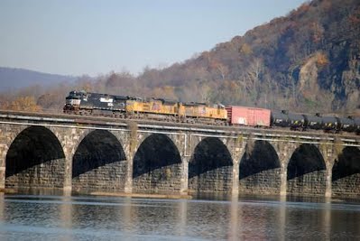
Just west of Brunswick MD along the C&O Canal (Amtrak, MARC, CSX) and the CSX main adjacent to US Route 340. The photo above was taken at Weverton Junction in July of 2014.

Harpers Ferry, WV Amtrak Station

(Amtrak, MARC, CSX) – Take pics at the Amtrak station or walk across the Potomac and take pictures of trains (not many a day) coming on and off CSX’s Winchester Branch. Harpers Ferry provides a beautiful backdrop for train watching where two rivers come together and three states border each other. There are two dramatic railroad bridges, a Victorian-era depot, and a charming historic town. There are shops and restrooms in town, which is managed by the National Park Service. Access to the downtown historic area where the station is is limited and parking may or may not be available.

The scenic town of Harpers Ferry is located at the confluence of the Potomac and Shenandoah Rivers. At this picturesque spot, the tracks of the CSX Cumberland and Shenandoah (Winchester Branch) Subdivisions cross the Potomac on separate bridges that form the sides of a V. The main line crosses the river at an angle on the “new” B&O bridge completed in 1931. This revised orientation of the river crossing eliminated what had been sharp curves on the approaches to the older bridges that were severely limiting from an operational perspective. The Winchester Branch crosses the river on an older bridge that dates from 1894 and proceeds through town on a wooden trestle. This bridge incorporates a pedestrian walkway on one side which enables the Appalachian Trail to cross the river. It’s possible to walk across the bridge in either direction which makes for an enjoyable hike. There are only occasional trains on the Winchester Branch but it is quite pastoral as it turns inland beyond Harpers Ferry and climbs away from the Shenandoah River. Both lines emerge from the Maryland Heights tunnel on the Maryland side of the Potomac just before the bridge crossings. The tunnel was constructed to reduce the curvature of the bridge approach on the Maryland side, and its western mouth was widened when the “new” B&O bridge was built.

Harpers Ferry has been the site of important bridge crossings since the building of the B&O railroad, and the current railroad bridges and the remains of old bridges create a dramatic setting. In fact, the bridge crossings themselves are on the National Register of Historic Places. Historically, the B&O had difficulty acquiring the needed right of way on the Maryland side of the Potomac for its route west. This led to the decision to build the line on the West Virginia (then Virginia) side and to bridge the river at Harpers Ferry. Although this solved the right of way problem, it made the railroad vulnerable during the Civil War and it experienced frequent raids by the Confederates.

Harpers Ferry is the site of the abolitionist John Brown’s raid on the Federal arsenal in 1859. The raid inflamed tensions between the North and the South and brought the nation closer to civil war. Part of the town is designated as Harpers Ferry National Historical Park. The town has considerable charm due to the large number of 19th century buildings in the Lower Town, its extremely picturesque location along the river front and up the side of the bluffs, and its steep roads and paths. Its strategic location led to a number of major Civil War battles. At one time a significant manufacturing and transportation center, Harpers Ferry today is primarily oriented towards the tourist trade. The area also offers considerable recreational opportunities for fishing, canoeing, rafting, and tubing and the Appalachian Trail has its headquarters here. St. Peter’s Roman Catholic Church is on the National Register of Historic Places. Built in 1833 and altered to its current appearance in 1896, it provides good views from its prominent position on the bluffs overlooking the area. Taken together, the historic setting, the confluence of the rivers, the steep cliffs, and the bridge crossings combine to create a uniquely scenic and picturesque backdrop for train watching.

Access to Harpers Ferry is from U. S. Route 340 several miles west of the Potomac River crossing and about a mile west of the bridge over the Shenandoah River. There are two ways to get to the station (112 Potomac Terrace) and the historic Lower Town: (1) park at the National Park Visitor’s Center (fee) and take the shuttle bus to the Lower Town (a good option at busy times) or (2) turn onto Union Street and then turn right at Washington Street. Follow Washington Street down the hill through town to the depot and Lower Town commercial area. Limited parking is available in this area but parking can be a challenge at busy times. There are places to eat, ice cream shops, etc. in the general vicinity of the station.

The station and the railroad at Harpers Ferry hug the river front. The station, another surviving Baldwin design, is a wooden frame, Victorian-style structure that was built in 1896. It is located right at the end of the new Potomac bridge and part of the platform actually extends onto the bridge. The station recently received an extensive renovation and the signal tower at the end overlooking the Potomac that had been removed sometime in the past was restored. The station was moved a considerable distance to its current location when the main line was realigned over the new bridge in 1931 and it sits on the buried foundation of the ruined armory building. Both the Amtrak Capitol Limited and MARC commuter trains stop here. The station is a popular place for photography, especially of west bounds coming across the bridge. A number of pictures of the station and immediate area can be found by clicking here.


The Maryland side of the Potomac across from Harpers Ferry is also worth a visit. One option, as mentioned, is to walk across the bridge from Harpers Ferry. To get there by car, take the first turn off of U. S. Route 340 onto route 180 (Keep Tryst Rd.) after crossing the Potomac bridge. Go a short distance and turn right on Sandy Hook Road. After squeezing through the small community of Sandy Hook between the tracks and the houses, the road crosses over the tracks on a narrow bridge near the east entrance to the Maryland Heights tunnel and then passes under the ends of the railroad bridges where the tracks exit the tunnel. This part of the C&O canal towpath is very scenic with excellent views of the river and there are some small parking lots along the road here. It’s possible to park here and walk across the bridge to Harpers Ferry.

Thanks to member Hank Anderson for contributing to this page.


Fredericksburg, VA Amtrak Station

(Amtrak, VRE, CSX) – Post 9/11 security makes standing here and taking pictures tough. There is a park a little farther North where the railroad crosses the river and you can get some good “landscape” shots.

Ashland, VA, including the Amtrak Station

(Amtrak, CSX) – CSX has a very busy double track main right through the heart of town with a 35 mph speed restriction (street running). This is the old RF&P railroad. Lots of places to eat, sleep, and stay nearby and the town is very picturesque. This is about two hours from DC. Photography is EASY! The photo at the left is just after a 2009 snowstorm.

Manassas, VA

(Amtrak, NS) – The Amtrak downtown station sees quite a few VRE and Amtrak trains during the week and has some historic cars nearby. A little further south the WYE carries NS traffic toward the Front Royal Line and sees heavy fr

Shenandoah Junction, WV

 (Amtrak, NS, CSX, MARC) – Here the former B&O main (now CSX) crosses under the former N&W Valley line (now Norfolk Southern). Both lines are heavily used freight lines. Be careful not to trespass in this location, but it is a great and popular location for local railfans. No immediately available restroom facilities, food, or gas in town.

Doswell, VA

Located on Doswell Road off of Route 1 near Kings Dominion – (Amtrak, CSX, Buckingham Branch) CSX’s doubletrack former RF&P main (north south) is crossed by the single track east west former C&O mountain division, now the Buckingham Branch railroad. A road crossing is a great place to take photos. You will see lots of Amtrak and CSX freights on CSX and mostly westbound empty coal and grain trains on the Buckingham branch. Fairly easy and nice place to take pictures, with the former C&O station still in use (as an office) and a former interlocking tower protecting the diamond. No services are readily available however and no restroom facilities. There is also a very unique Antique store here.

Rockville Bridge - Marysville - Duncannon, PA

This is the Norfolk Southern Main line but it also typically hosts at least two Amtrak trains a day. It has the best scenery along the Susquehanna River and probably twice as many freight trains as any of the other locations (60-70 per day).  The photo on the right by Ira Silverman is of Rockville Bridge. Photo by Ira Silverman.

There is a railfan oriented bed and breakfast with great views of the bridge and river – Bridge View Bed and Breakfast – in Marysville, PA.

Other interesting areas

though not necessarily “Railfan HotSpots.” Best time for these spots is weekends.

  • Martin Airport – Trains on the Northeast Corridor) and A-10s and C-130s. Trains are more prevalent on weekdays when MARC and Amtrak typically run more trains.
  • Baldwin Station in Sykesville – Next to CSX’s “Old Main Line” also, but has a very nice restaurant in the former B&O station. Als nearby are a restored B&P switch tower, a 1910 C&O Parlor car with a model railroad layout in it (open first Sunday of month), and a caboose. Several slow lumbering freights a day.

Freight Trains on the Northeast Corridor

Freight trains are sparse on the Northeast Corridor. Havre de Grace/Perryville has trains coming from Harrisburg going north towards Wilmington and south to Baltimore. The Baltimore trains also cross the river to Havre de Grace. 

Photographers' Rights

In the last few years people photographing trains have often been the subject of heightened police attention. We are not an authority on the subject, but generally speaking, photography of a train from a public place is Constitutional, but the rules often vary by railroad and jurisdiction. However, we caution you to use common sense, to be cooperative with police, railroad officials, and other authorities, and to not trespass.


NOTE

Be responsible and safe when railfanning in these areas. Security concerns remain high in this area. Please stay off the tracks and do not trespass. Expect a train on any track from any direction at any time.